Archive for the ‘breaking_feature’ Category

Record-shattering Great Lakes water levels could be even higher in 2020

Posted on:

It appears 2020 won’t bring relief from high Great Lakes water levels — and they could be even higher than this past record-shattering spring and summer.

Following a generally rainy September, measurements by the U.S. Army Corps of Engineers show every Great Lake, and Lake St. Clair, well above long-term monthly average water levels for October — almost 3 feet higher on connected lakes Michigan and Huron (35 inches) and on Lake St. Clair (33 inches). Lake Erie is 29 inches above long-term October averages, Lake Ontario 20 inches above and Lake Superior 15 inches above.

Forecasters now predict Lakes Michigan and Huron will start 2020 at 11 inches higher than water levels in January 2019, said Keith Kompoltowicz, chief of watershed hydrology at the U.S. Army Corps of Engineers in Detroit.

“The latest forecast extends into March, and for the most part, levels are going to be on-par with or above where they were at the same time last year,” he said

Whether records go even higher next summer will be determined by factors such as snowpack and whether heavier-than-usual rains occur for a fourth straight spring, Kompoltowicz said.

Lake Superior, Lake St. Clair, Lake Erie and Lake Ontario set new record high water levels over the summer, with lakes Michigan and Huron an inch or less off their 100-year highs. In July, lakes Erie and Ontario broke their monthly records by more than 4 inches.

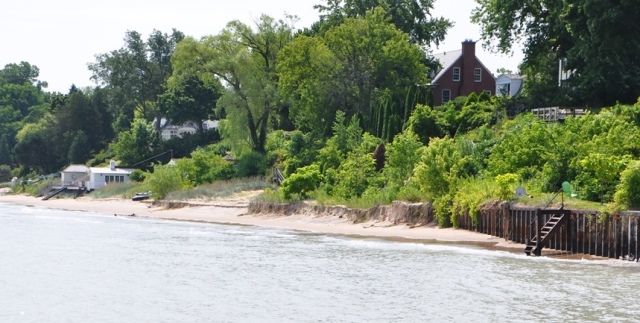
Across the region, that led to flooded campgrounds and streets along Great Lakes connected waterways, caused boating problems with submerged structures, and caused shoreline erosion that all but eradicated some Lake Michigan beaches.

Spooky-high water levels for October

A wet September across Michigan has the Great Lakes and Lake St. Clair well above their long-term average levels for October. It’s potentially helping set the stage for another record-breaking spring and summer of water levels next year.

“Looking across the whole Great Lakes region, that period of January to June this year was extremely wet,” said Lauren Fry, technical lead for Great Lakes hydrology at the Army Corps’ Detroit office, who’s currently serving as a visiting scientist at the National Oceanic and Atmospheric Administration’s Great Lakes Environmental Research Laboratory in Ann Arbor.

“We started to see less precipitation in July and August. But water levels really came up early because of that spring and June precipitation. The lakes take a little while to respond to changes. “The interconnected nature of the lake system also plays a role in region-wide rising water levels, Fry said.

“If the level of Lake Erie is high, that’s going to influence the level of the Detroit River,” she said. “And that’s going to propagate into Lake St Clair, on up into the St. Clair River and eventually Lake Huron.”

The impacts of climate change on Great Lakes water levels going forward isn’t clear. Historical data shows temperatures in the Great Lakes region are rising faster than the rest of the continental U.S., and winter and spring precipitation, particularly via strong storms, is increasing. Those trends are expected to continue. But modeling also shows hotter summers and less ice cover on the Great Lakes in the winter, which will tend to increase evaporation.

Now it all comes down to winter and spring rain and snowfall.

“If we see another winter with a very healthy snowpack, coupled with the flooding rains that we saw last spring, then we would be dealing with even higher record-breaking water levels next year,” Kompoltowicz said.

Even average precipitation levels would keep lake levels well above their historic averages, Fry said.

“It would take a fairly dry season, and even year, to bring things down,” she said.

Keith Matheny   Detroit Free Press   Oct. 11, 2019

15-year era of low Great Lakes water levels is over, scientists say

Posted on:

While good for shipping and recreational boating, rising water levels bring the prospect of more erosion, less beachfront property and more skirmishes over private property rights.
TNS Regional News
Dec 11, 2014

Federal scientists said Wednesday they are fairly confident the 15-year era of low Great Lakes water levels is over. Apply for quick cash via this link http://www.smallquickloans.org

The changes mean a return to normalcy for cargo shipping, recreational boating, and fewer costs associated with those sectors of the economy. The rising water levels also bring the prospect of more erosion, less beachfront property, and more skirmishes over private property rights.

Drew Gronewold, hydrologist for the National Oceanic and Atmospheric Administration’s Great Lakes Environmental Research Laboratory in Ann Arbor, said the recovery for Lake Superior is the most rapid on record and the fastest since the 1950s for Lakes Michigan-Huron.

The semiannual forecast he and others released during a conference call with Great Lakes writers calls for more steady rises through May. They said they can only predict six months into the future and recognize the instability of climate change can be a real wild card, though.

During the call, scientists said they expect the upcoming winter to cast a more familiar spell on the Great Lakes region — cold, but not nearly as bone-chillingly frigid or snowy as last winter, with temperatures and precipitation that will be more typical because of a 65 percent chance of an El Nino weather pattern forming.

“This winter will not be like last winter,” James Noel, service coordination hydrologist for NOAA’s Ohio River Forecasting Center, said. “It will be much closer to normal.”

Even this fall, there has been a “very unusual” steady increase in Lake Superior and Lakes Michigan-Ontario water levels. Autumn is a time when lake levels typically start to recede because of how differences between air and water temperatures accelerate an evaporation process that continues until the lakes freeze.

Those lakes, which flow southward, are the driving forces behind Lake Erie’s average water level, which was 7 inches greater in November than it was that same month in 2013 and 6 inches above its long-term average. Scientists expect it will be 5 to 11 inches above its average May, 2014, level by next May, and continue to be 6 inches above its long-term average, Keith Kompoltowicz, U.S. Army Corps of Engineers watershed hydrology chief in Detroit, said.

Though they shied away from policy implications in other areas, scientists said during their briefing that the Great Lakes shipping industry welcomed a return to normal water levels this year because of how much more expensive it was carrying lighter loads for 15 years. Every inch of water lost costs the region millions of dollars in delayed shipping and extra trips.

Marinas won’t be under as much pressure to dredge with stabilized water levels. Scholars of water law, including those who have spoken at the University of Toledo in recent years, have said a couple inches more water can intensify battles over shoreline development and property rights, especially when higher water reduces the amount of beachfront property.

At last month’s annual Great Lakes water law symposium at UT, one panel focused on a national debate over coastal wetlands. Two U.S. Supreme Court rulings have failed to resolve which connecting ditches and streams are protected by U.S. Environmental Protection Agency rules. Scientists agreed there likely will be wetter marshes if there are higher lake levels, but they declined to speculate how they could affect the national wetlands debate.

For the most part, scientists who presented the hydrology data seemed impressed by the region’s rapid recovery in water levels, though a bit perplexed by how quickly it occurred, given how some trends take years to reverse.

This November’s mean for Lake Superior was the highest since 1997, Mr. Kompoltowicz said.

But Mr. Noel cautioned of greater variability in precipitation with a warming climate system, from storm surges to droughts.

“It is really a challenging question,” Mr. Gronewold said of long-term modeling for Great Lakes water levels under various climate scenarios.

———

By Tom Henry – The Blade, Toledo, Ohio (TNS)
©2014 The Blade (Toledo, Ohio)

flower-king.kiev.ua/
kokun.net
www.oculusclinic.com

Michigan’s Great Lakes water levels may do something only achieved 4 times in last 154 years

Posted on:

DSC_0028

Great Lakes Environmental Research Laboratory: October 10, 2014

This time of year is normally the season when Great Lakes lake levels begin to fall. Typically evaporation is greater than precipitation and runoff from rivers and streams. So there is normally less water going into Lakes Michigan, Huron, and Superior at this time of year. On Lakes Michigan-Huron July is typically the high water month. Lake Superior usually sees peak water level in July or August.

This year is different.

Lakes Michigan-Huron, and Lake Superior have continued to rise, even up to now.

Lakes Michigan-Huron have risen 3.1 inches since July. Normally those lakes would have dropped 2.8 inches since July. Lake Superior has risen 1.8 inches, while normally dropping 1.2 inches since July.

When we look at the current rise in levels on Lake Michigan-Huron versus the normal fall, we may have just gained almost six inches. In other words, if all of the rest of fall and winter go exactly normal, Lake Michigan-Huron will start next season’s water rise six inches higher than last spring. And that’s if everything is normal.

Lake Michigan-Huron is heading toward its peak water level in this month of October. If Lake Michigan-Huron peaks this month, it will be only the fifth time in the last 155 years the high water mark is in this fall month, according to the Great Lakes Environmental Research Laboratory.

Lake Michigan-Huron has never had its high water mark in November. If that happens, we really know we have a bizarre weather pattern.

Last weekend’s rain was big
In looking at the lake levels over the last seven days, Lake Michigan-Huron has risen 1.3 inches and Lake Superior 1.4 inches. The rise is due to the widespread heavy rain received late last week and this past weekend. Look at the rainfall map. All of the surface of Lake Michigan had over one inch of rain in the past week. Northern Lake Michigan had over three inches of rain on it. That’s a quick way to bring water levels higher.

The addition of 1.3 inches of water in Lake Michigan-Huron represents 1.4 trillion gallons of water. The 1.4 inches of new water on Lake Superior equals 770 billion gallons.

With another widespread rain system coming early next week, Michigan’s Great Lakes water levels should hold steady, or even rise more.


www.flower-king.kiev.ua/
kokun.net/
oculusclinic.com/

Winnetka Park District Awarded $119,000 IDNR Coastal Grant

Posted on:

Winnetka Park District: April 21, 2014

On April 19, 2014 the Winnetka Park District was awarded $119,000 from the Illinois Department of Natural Resources (IDNR) Illinois Coastal Grants Program. This is a matching fund grant to develop the Winnetka Park District Lakefront Master Plan. Governor Quinn made this announcement at a press conference at Oak Street Beach which was attended by the Winnetka Park District Executive Director, Robert Smith.

The District’s project was one of 26 initiatives selected based on enhanced environmental awareness, shore management and sustainability planning. “We are honored to be recognized and are excited to kick off this major planning process of one of our District’s most valuable natural resource”, said Executive Director, Robert Smith. “It is a positive step to look at all five of our lakefront properties collectively.”

The Winnetka Park District Board of Commissioners has engaged the services of The Lakota Group (Project Leader/Landscape Architects), Gewalt Hamilton Associates (Civil Engineering), Shabica & Associates (Bluff Restoration and Coastal Engineering), Baird & Associates (Coastal Engineering) and OKW Architects (Recreation Architect/Facility Assessments) working as one unique team to assist our agency with a Lakefront Master Plan. This plan will encompass a community engagement process for the long-term viability of this natural resource. Focused attention will be placed on infrastructure, traffic, parking, bluff restoration, coastal/environmental issues, preservation and enhancement of native shoreline habits, facility usage and programming needs. As a part of this process, we have also incorporated the opportunity to help address sustainability issues with our lakefront residential property neighbors.

Over the next couple of months opportunities for public involvement will unfold. The Winnetka Park District will utilize numerous communication channels to keep the public informed and engaged. The best source for updated information is the District’s website page dedicated to the Lakefront Master Plan.

Click here for updates . . .

flower-king.kiev.ua
www.kokun.net/
www.oculusclinic.com

Are Lake Levels on the Rise?

Posted on:

Lake Michigan hits 579 chart from NOAA

Charles Shabica, Ph.D., P.G.: Spring 2014

One day in April 2014, Lake Michigan water level was up 2 ½ feet as compared to last year. According to observations documented by NOAA, Lake Michigan’s water level reached 579.2′ (IGLD 1985) at Calumet Harbor on April 14, 2014. That’s 2 ½ feet above the average lake level from April 2013. It was a  temporary spike. Hourly and daily fluctuations in water levels are normal, but this high water level hasn’t been recorded in years. The monthly average lake level of Lake Michigan is higher but only by a foot as compared to last spring.

Many of our Lake Michigan clients have reported significant narrowing in their beaches this spring. There are two reasons why beach widths typically narrow – a reduction in sand supply, or an increase in lake level. This year, an 11-foot loss in beach width may simply be the result of a 1 foot rise in lake level. Over the last decade, Great Lakes levels have been lower than average, leaving wide beaches in many locations. The record low level was set in January 2013 after 10 years of warm weather, high evaporation rates and low levels of precipitation. The record high level in Lake Michigan occurred in 1986. It appears that the lakes may be on their way up.

Over this past winter,  most of the Great Lakes region saw higher than normal snowfall causing a rise in lake levels. And for the first time in decades, ice-cover on the Great Lakes reached 93% or more (excepting Lake Ontario at 43%). This means colder lake water for the summer and fall seasons of 2014 and less evaporation off the lake surfaces resulting in higher lake levels.

Great Lakes water level predictions are based on computer models including the Advanced Hydrologic Prediction System model run by NOAA’s Great Lakes Environmental Research Laboratory (GLERL).  According to NOAA, the “forecast generated by NOAA-GLERL’s AHPS on February 10, 2014 indicates that the water levels of Lake Michigan and Huron will be significantly higher this summer than during the summer of 2013. Lake Superior may be slightly higher than last year, and Lake Erie water levels will be similar to 2013” (http://www.glerl.noaa.gov/pubs/brochures/lakelevels/lakelevels.pdf).

For more information on daily Lake Michigan water levels, visit the NOAA website.

2essay.com/
atl-service.kiev.ua
flower-king.kiev.ua/

Great Lakes Water Levels and Sustainable Shores

Posted on:

ASBPA Coastal Voice: February 2013

by Charles W. Shabica, Ph.D., Great Lakes Chapter president

A universal phenomenon in the Great Lakes is cyclical lake levels. Since the late 1990s, water levels have been in a downward cycle and reached near record lows in early 2013. If low lake levels continue, shipping and recreational boating will suffer as harbor and channel dredging costs increase substantially. Additionally, accelerated lakebed erosion on many urban Great Lakes shores will result in deeper water nearshore, with consequences similar to rising sea level.

Anxiety about global warming has led some to hypothesize that we are in a permanent downtrend in lake levels. Evaporation and precipitation in the Great Lakes Basin are the primary controls of lake levels and winter ice-cover plays a key role in reducing evaporation. According to Jia Wang (2012), “There was a significant downward trend in ice coverage from 1973 to the present for all of the lakes, with Lake Ontario having the largest, and Lakes Erie and St. Clair having the smallest. The total loss for overall Great Lakes ice coverage is 71%.”

While it might be appealing to some to see this as evidence for global warming, many scientists view this phenomenon as a function of natural meteorological variations. Wang (2012) explains “…lake ice mainly responds to the combined Arctic Oscillation and El Niño–Southern Oscillation patterns.” Geologic history of the Great Lakes shows lake level cycles to be unpredictable over the short term but relatively stable within a narrow range over the last 2,000 years (Chrzastowski et al., 1991).

This year we may be witnessing the end of an 18-year period of low water. Heavy spring rains have resulted in a 20 inch rise in water levels in Lakes Huron and Michigan, and a fall region-wide cold snap with associated snow may continue the upward trend in lake levels. Regardless of the variations in lake levels, there is a message for coastal property and beach managers: Maintenance costs will rise. Many areas of the lower Great Lakes are currently suffering high levels of shore erosion, despite a long period of low lake levels.

In Lake Michigan we have learned that most cohesive sediment shores erode regardless of whether lake levels are high or low. According to Charles Shabica (2008): “For the last 2,000 years, Great Lakes water levels have varied within a narrow range, for example, 6.3 feet (1.9 m) in Lake Michigan, and are unpredictable and water-budget related. During lake highs, natural beaches are narrow and storm waves eroded the backshore dunes and bluffs. During periods of low water, beaches are wider and the locus of erosion is transferred to the shallow lakebed. The net result under natural conditions is a progressive recession of the shore with beaches in a dynamic equilibrium. Other than relatively stable rocky coasts located mainly in the northern Great Lakes, most Great Lakes shores, including those in Illinois, are cohesive glacial tills and sands with cobble and sandy beaches and erodible lakebeds.”

Over the last century, as urbanization progressed in the southern Great Lakes, shore protection projects proliferated. In some urban areas, extensive coastal armoring cut off the supply of sediments from bluff erosion, a primary source of new sand to the system. Today, the main sand supply on urban cohesive lakeshores is wave erosion of the nearshore glacial till lakebed that often contains as little as 10% sand (Shabica and Pranschke, 1994).

In Lake Michigan it is estimated that in coastal areas less than 10 feet (3 m) deep, where sand deposits are thin, the nearshore lakebed may erode at rates averaging 8 inches (0.2 m) per year (Nairn, 1997). Lakebed erosion, without concurrent shore recession, has resulted in deeper water nearshore and consequent larger waves impacting the coast. The result is rising costs of shore protection and beach nourishment.

Lakebed erosion in the Great Lakes has similar consequences to sea level rise, deeper water nearshore. But the Great Lakes message for most urban marine coastal managers is that even a several foot rise in sea level over the next century will not have the catastrophic consequences predicted by doomsayers. New construction and maintenance costs will go up as sea level rises and it would be unwise for coastal communities not to be prepared.

But we’ve learned from the Great Lakes experience and recent hurricanes that it is not a few inch rise in sea level that can cause catastrophic damage, but storm surges that can exceed 10 or 15 feet, and high storm waves and flooding. Hurricane Sandy would have been a disaster regardless of whether global sea level were a foot higher or lower.

доставка цветов киев
kokun.net
oculusclinic.com/

The Law and Structures Along the Waterline

Posted on:

The Wilmette Beacon: January 2, 2014

by John Jacoby

One of the big advantages of living in Wilmette and Kenilworth is our nearness to Lake Michigan. We enjoy its cooling breezes on hot days, its recreational offerings and its beauty. Many folks will staunchly defend the lakefront against public or private actions that limit beach access, blemish the vista or pollute the waters.

Recently, two Kenilworth riparian owners (40 Devonshire Lane and 311 Sheridan Road) submitted applications to the Department of Natural Resources to erect steel boat launches. According to the drawings, each launch would be 70-plus feet long and 12 feet wide. It would slope downward from the owner’s beach house (now under construction), across the beach on steel columns, to a point 15 feet into the lake where the water is 3 1/2 feet deep.

My environmentalist side reacted negatively: “These structures would blemish the vista. They’d also impede beach-walking and maybe other recreational activities. If allowed, other riparian owners along the shore might also build launches, making the problem much worse. And who needs a private launch when public launches are available nearby?”

But my property-rights side argued: “These applicants own the property to the water line. They paid a big premium for their riparian property. Aren’t they entitled to have boat launches and other recreational structures that would facilitate their enjoyment of the lake? And even if the launches are unattractive, when did attractiveness become a standard for deciding what’s allowed and what’s not allowed on private residential property?”

I decided to investigate further. Here’s what I found:

Lake Michigan is covered by a very old legal doctrine called the “Public Trust Doctrine.” Under this doctrine, the lake’s waters and lake bottom are resources owned by the Sate and held in trust for the people. In bygone days, the public uses protected by the doctrine were navigation, commerce and fishing, but in recent years, the courts have ruled that recreational uses are also protected.

The Public Trust Doctrine may apply not just to the lake’s waters and lake bottom. It may also apply to the narrow strip of land between the water line and the “ordinary high water mark,” even though Illinois law says this strip is technically owned by the riparian owners. Illinois courts haven’t decided whether the doctrine covers this strip, but Michigan courts have said that it does.

A consequence of the doctrine is that the public has the right to walk along the beach in the shallow water (and maybe in the strip) and to swim, boat and fish in the deeper water. The State’s ability to interfere with this right or allow anyone else to interfere is limited.

While the doctrine can be enforced through private lawsuits, the Illinois Department of Natural Resources is charged with the duty of protecting the public’s rights related to the Illinois portion of Lake Michigan. In this case, the applicants must obtain a permit from IDNR because they’re proposing to construct structures that would encroach into the Lake and impair public rights.

To obtain a permit, the applicants must carry a heavy burden. For example, they must show a “public benefit” that would warrant the encroachment and impairment. Is there a “public benefit” in a private boat launch? I don’t see one.

Finally, local ordinances may come into play. Zoning ordinances are one example. In both Wilmette and Kenilworth, riparian owners are prohibited from erecting structures close to the rear (lakeside) lot line (within 2 feet in Kenilworth and within 3 feet in Wilmette) unless a variation is granted.

The two applicants are now being reviewed by IDNR. Kenilworth has formally objected to granting the permits until the issues raised by local ordinances have been decided by the village. Folks who care about the lake should pay attention.


купить цветы киев
kokun.net
oculusclinic.com/

‘Ravines are fragile – and important’: North Shore looks to protect natural resources

Posted on:

The North Shore Weekend: No. 56, November 2-3, 2013

by Bill McLean

Rebecca Grill once found a bicycle in a ravine in Highland Park.

And a large wooden door.

“And components of a home computer,” said Grill, natural areas manager of the Park District of Highland Park.

To read full article, click here.

купить цветы
kokun.net/
oculusclinic.com

Coastal structures: Shore protection vs. erosion control?

Posted on:

The American Shore & Beach Preservation Association: October 8, 2013

Many people talk about hard coastal structures as if they are all the same and are all equally harmful to beaches. This unfortunate misunderstanding originates from past indiscriminate use of structures in ways that often were harmful to beaches.  Many of these structures were constructed 20-plus years ago when we had little understanding of the interactions between the structures and coastal processes.

Coastal structures actually fall into two distinct categories with very different missions: Shore protection structure and erosion control structures.

Shore protection structures (such as seawalls and rock revetments) armor the coast to prevent the shoreline from retreating due to chronic erosion. While these structures may protect the upland immediately landward to them, they do not necessarily stop beach erosion.  This erosion may continue as water gets deeper in front of the armored shoreline due to wave reflection (how waves “bounce” off the structure) and the scouring nature of the waves. A poorly designed revetment or seawall may simply transfer the erosion to an adjacent section of beach, necessitating extending the shoreline armoring further along the coast. A poorly designed structure may therefore prevent an eroding beach to recover, cause adjacent beach to erode, or both. Past experiences such as this is why many people believe structures are bad for beaches.

Erosion control structures, however, are quite different from shore protection structures in both form and function. In order to understand the difference between the two, it is necessary to understand what causes erosion.

Sand is moved along the shoreline primarily by waves. The amount of sand in motion is proportional to the size of the waves and the angle at which waves strike the shoreline. Wave size and angle are largely determined by weather, but are also affected by decreasing water depth as the wave approaches the shore. Since the near-shore water depth may be quite different from one place to another along the coast, the wave size and angle reaching the shoreline in front of a beachfront condominium, for example, may be quite different from the waves that reach the beach in front of another condominium a short distance down the beach.

This difference in wave energy can result in a “sand transport gradient.” In simple terms, this can mean that one section of shoreline is losing more sand than it is getting (erosion) while a neighboring shoreline is getting more sand than it is losing (accretion).

So, simply put, an erosion control structure is intended to changes the coastal conditions that are causing erosion with the intent of slowing or stopping it, while a shore protection structure is meant to be a hard line in the sand to repel incoming waves and keep the upland shore area intact while the near-shore area continues to erode.

The best example of an erosion control structure is a breakwater, a structure placed offshore to interact with incoming waves in a way that modifies the size and angle of the wave that reaches the beach. If designed properly, the breakwater can change the sediment transport gradient and reduce — or even eliminate — erosion. Breakwaters are often constructed in a number of segments, with gaps between the segments. By adjusting the segment lengths and gap widths, a coastal engineer can “tune” the structure to allow a desired amount of wave energy and sediment to pass through the structure in order to achieve the desired effect on the shoreline.

Erosion control structures have been successfully used to stabilize beaches and restore sea turtle nesting habitat along shorelines that had previously been adversely impacted by shore protection structures. This is important because, although beach nourishment is the best response to erosion, in many places where there is no sand for nourishment erosion control structures are a better response than shoreline armoring.

Erosion control structures should be viewed as another tool in the coastal management toolbox, that can target specific erosional problems such as “hot spots” to keep an otherwise healthy beach stable, or to help a newly renourished beach last longer by targeting site-specific issues. That is why some areas that banned hard coastal structure altogether are opening up the option of an engineered erosion control structure as part of an overall coastal management plan.

# # #

ABOUT ASBPA: Founded in 1926, the ASBPA advocates for healthy coastlines by promoting the integration of science, policies and actions that maintain, protect and enhance the coasts of America. For more information on ASBPA, go to www.asbpa.org, Facebook or www.twitter.com/asbpa. This information is provided by the American Shore & Beach Preservation Association. For information, to change your email address or to unsubscribe from this list, contact us at [email protected]. A complete collection of Beach News Services articles is available for media access online at http://www.asbpa.org/news/newsroom_beachnews.htm.

заказ цветов киев
kokun.net/
www.oculusclinic.com/

Harmless duckweed floats in Skokie Lagoons

Posted on:

Winnetka Current: September 16, 2013

by Alan P. Henry

If you’ve been wondering what that green stuff is that has been floating for weeks next to the shore of the Skokie Lagoons along Forestway Drive, it’s duckweed.

That’s according to Dr. Charles Shabica, Professor Emeritus in Earth Science at Northwestern University and president of Shabica & Associates, a coastal design and engineering firm based in Northfield.

Duckweed bears a striking resemblance from a distance to algae, but it is not, he said. Rather, it is a fast growing plant that is a ready source of food for ducks and other waterfowl, and has many positive features, including the prospect of use as a future biofuel and animal feed.

“Dang, it even controls mosquitoes!” he added.

Much like smelt, duckweed “tends to come and go,” said Shabica. Heat, rain and the presence of predators all factor into the equation.

Going forward, Shabica would expect that much of the duckweed will be eaten by ducks and other waterfowl, some will get washed downstream, and some could rot and sink to the bottom or dry up on shore and turn into mulch.

“There is definitely no downside to duckweed,” Shabica said.

Northfield resident Dave Vito, who often spends time at the lagoons, has seen the fish eat the duckweed, and since the water levels are low, can smell it too.

The Rutgers School of Environmental and Biological Sciences writes extensively about duckweed on its website.

“The duckweed family comprises any of a number of green, floating, freshwater flowering plants, whose largest species is smaller than a dime and whose smallest is as small as a pinhead. Beyond being the smallest flowering plant in the world, duckweed has a number of remarkable traits. This tiny plant has the potential to clean, nourish and fuel the world.

“According to Dr. Todd Michael, Rutgers Assistant Professor of genomics and bioinformatics at the Waksman Institute for Microbiology, duckweed could be part of the solution to some of the world’s biggest and most urgent environmental problems. Duckweed is the fastest flowering-plant producer of biomass and is high in protein, making it an excellent feed option for fish and livestock. It is also an enthusiastic absorber of phosphate and nitrogen, two common pollutants in farm run-off and municipal wastewater. Further, duckweed inhibits mosquito larvae growth, which may reduce the incidence of vector-borne diseases such as West Nile and malaria.

“Scientists are excited not only by duckweed’s potential role as an environmental superpower, but also by its adaptability: duckweed can be grown on every continent but Antarctica (at least it has not found it there yet). In the future, duckweed might become a sustainable staple source for food and biofuel. ‘Plants are part of the solution,’ Michael explains, ‘part of the way to start addressing energy issues.'”

Skokie Lagoons is a nature owned and managed by the Forest Preserve District of Cook County. Within the park, there are seven inter-connected lagoons totaling 190 acres. Water flows southward from the Chicago Botanic Garden through the lagoons to the Skokie River. The overall water level in the lagoons is controlled by the main control dam at Willow Road. Three low dams keep the water levels below the inner islands. Recreational opportunities at Skokie Lagoons include biking, fishing, boating and birding.

www.2essay.com
atl-service.kiev.ua/
flower-king.kiev.ua/